


Extreme rainfall induced risk mapping for metro transit systems: Shanghai metro network as a case
文章作者(*為通訊):
1. Dongming Zhang?1,3,*
2. Hao Bai?1,3
3. Canzheng Zheng?5
4. Hongwei Huang?1,3
5. Bilal M. Ayyub?2,3,4
6. Wenjun Cao?6
作者單位:
1.Key Laboratory of Geotechnical and Underground Engineering of Minister of Education and Department of Geotechnical Engineering, Tongii University, Shanghai 200092, China
2.Center for Technology and Systems Management, Department of Civil and Environmental Engineering, University of Maryland, College Park, MD,20742, USA
3.International Joint Research Center for Resilient Infrastructure, Tongji University, China
4.Applied Economics Office, National Institute of Standards and Technology, Department of Commerce, USA
5.Jinan Rail Transit Group Co., Ltd, Jinan, China
6.Department of Civil Engineering, the University of Hong Kong, Hong Kong, China
關鍵詞:
Risk assessment; Metro flooding; Extreme rainfall; Multi-layer network; Resilience.
原文鏈接:
https://doi.org/10.1016/j.ress.2025.111234
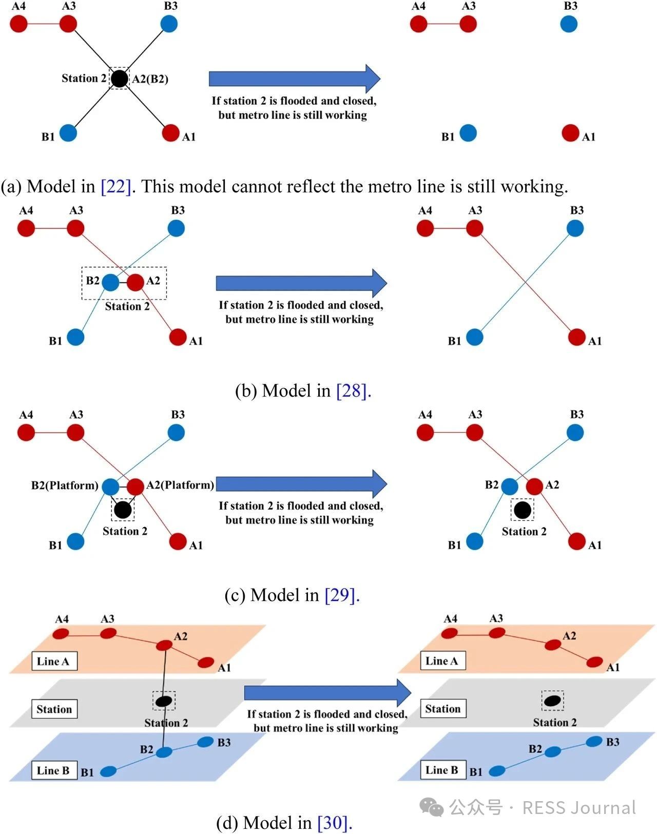
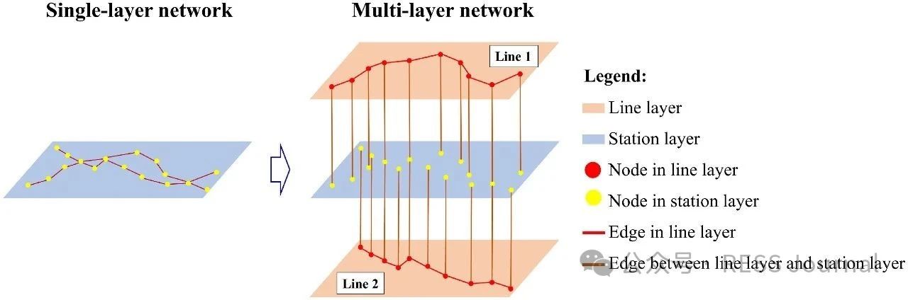
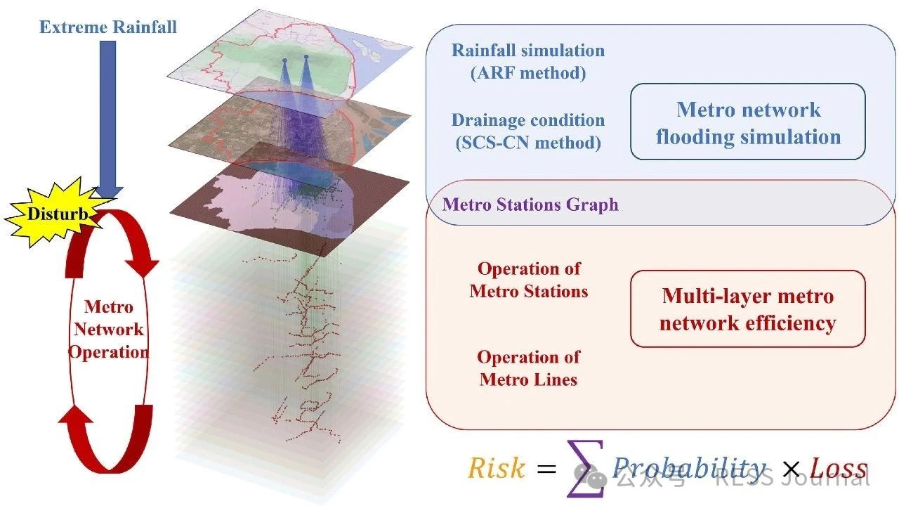
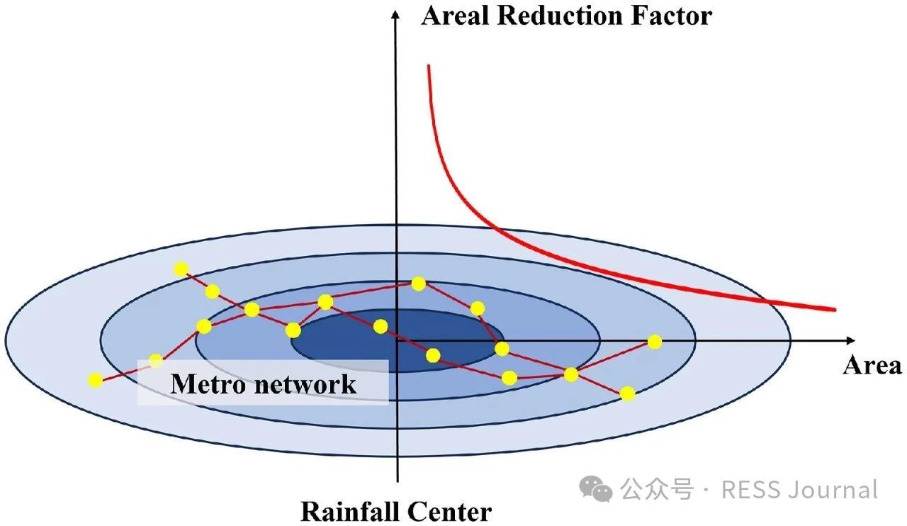
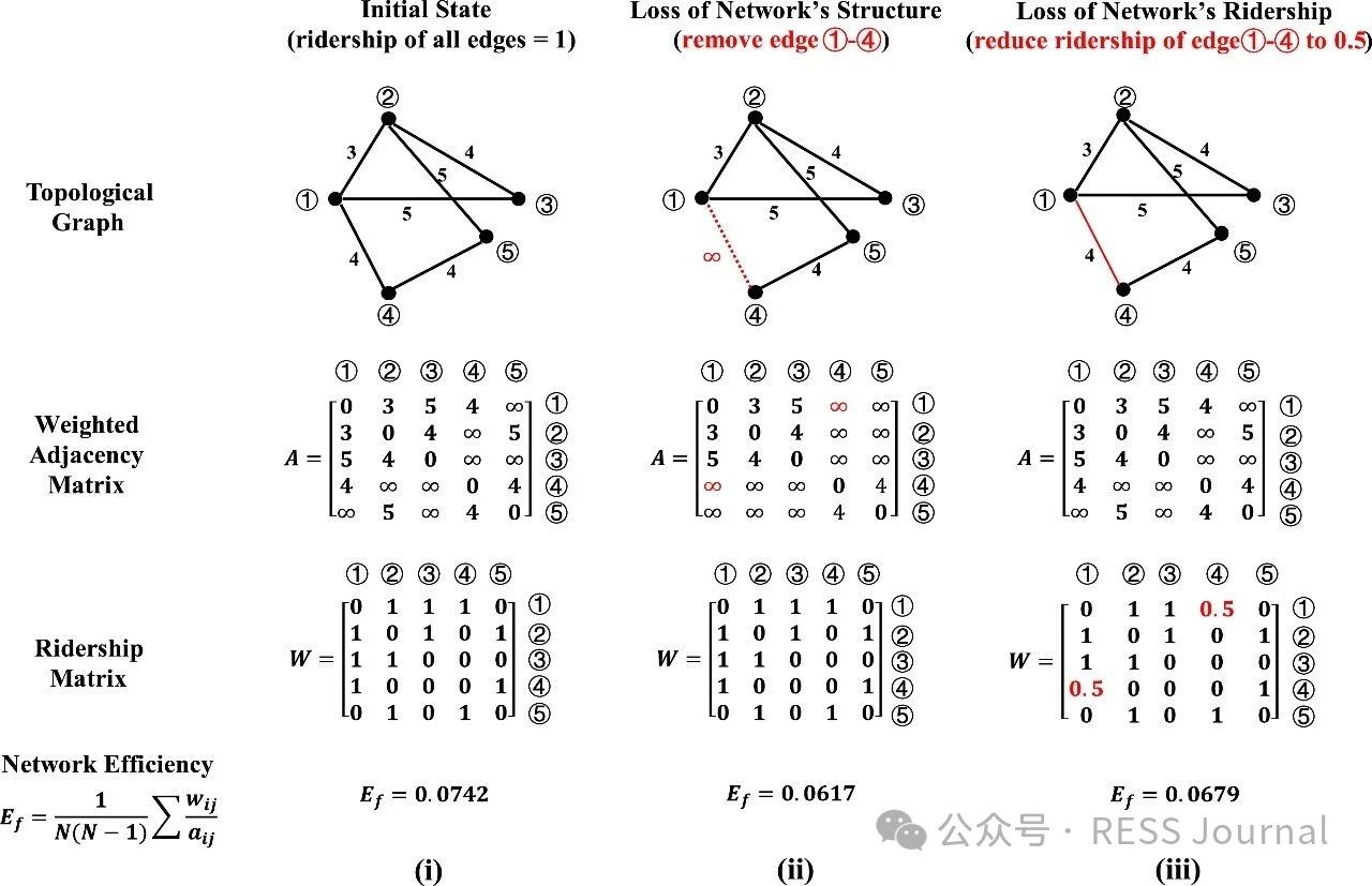
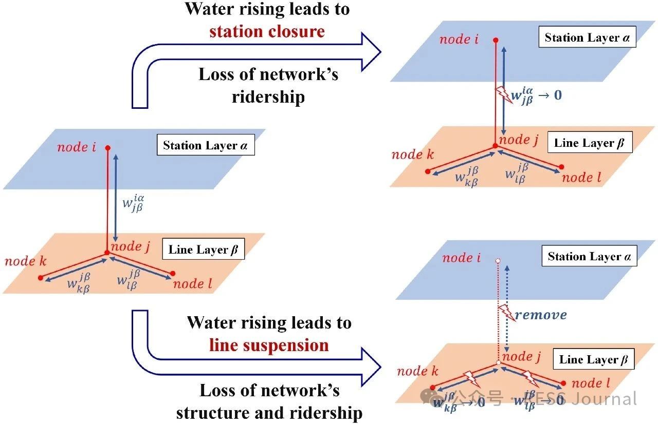
In recent years, a changing climate has induced flood risk as a great threat to the safety and reliability of the metro transit network in mega-cities. A highly networked metro system can lead to a quick spread of this risk, and furthermore, the impact range of single-node accidents of a network is nonlinearly amplified through network connectedness defined by its topology. This study proposes a risk assessment framework integrating extreme rainfall simulation and network loss analysis. The methodology employs the Areal Reduction Factor (ARF) and Soil Conservation Service Curve Number (SCS-CN) to model rainfall-induced flooding, coupled with a multi-layer network-based approach that distinguishes topological interactions between stations and lines. Taking Shanghai metro as an example, this paper highlights its risk follows an exponential distribution to extreme rainfall events, characterized by the finding that nearly 50 % of extreme rainfall events result in <5 % network loss, whereas fewer than 5 % of the events lead to >50 % network loss. When rainfall centers are located in the urban center where metro stations are densely distributed and intricately connected, or when the rainfall intensity and the spatial distribution uncertainty increases, it will pose a greater risk to the metro network.
相關推薦:軌道交通展展位預訂??軌道交通展免費報名參觀

軌道交通展消息 根據提供的2025年10月中國城市軌道交通運營數據,以下進行深入分析。分析將涵蓋總體運營規模、客運量變化、運營效率、系統類型對比、進站量與客運量關系、運營管理等方面,并結合數據揭示趨勢和隱含問題。 1.?總體運營規模 城市覆蓋與網絡擴展:2025年10月,全國54個城市開通運營城市軌道交通,線路333條,運營里程達11330.5公里。這表明中國城市軌道交通網絡已非常龐大,覆蓋了絕大多數主要城市,成為城市公共交通的骨干。 客運量巨大:月客運量28.2億人次,進站量16.8億人次,日均客運量約9096.77萬人次。開行列車376萬列次,平均每日開行約12.13萬列次。這些數字凸顯了城市軌道交通在日常通勤中的關鍵作用,有效緩解了城市交通壓力。 無新開通線路:本月無新開通線路,但運營里程環比可能有所增加(計算顯示環比增加約474公里),可能源于現有線路的延伸或調整,而非全新線路投入運營。 2.?客運量變化趨勢 環比增長顯著:客運量環比增加1.3億人次,增長4.8%。這種短期增長可能受季節性因素影響,如10月黃金周假期帶來的出行需求增加,或經濟活動的短期復蘇。 同比增長放緩:客運量同比增加0.5億人次,增長1.8%。同比增長率較低,可能反映市場接近飽...
合作郵箱:chinaiut@sgexpo.cn
新聞熱線:021-3114 8748
廣告/媒體合作:13916277698
轉載內容版權歸作者及來源網站所有,本站原創內容轉載請注明來源
Copyright ? 晟格會展(上海)有限公司 版權所有 Powered by Tp滬ICP備18026942號-6 ![]() 滬公網安備 31011302006543號
滬公網安備 31011302006543號